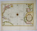
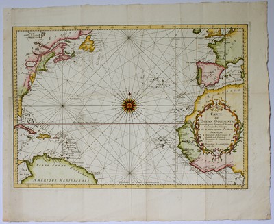
Carte de l'Ocean Occidental
Jacques Nicolas BELLIN
(1703 - 1772)
“Carte de l'Ocean Occidental
Dressée pour Servir a l'Histoire Generale des Voyages
Par M Bellin Ingenieur de la
Magnificent engraved map of the Northern Atlantic Ocean dated in the decorative cartouche 1746 and coming from the famous work of Prévost d'Exiles “Histoire Générale des Voyages” published in Paris by Didot from 1746 to 1789.
The map shows on the left side the coast of North America with the Colonies Florida, Carolina, Virginie, Pensilvanie, Nouvelle Angleterre, Nouvelle Ecosse and Acadie, all the West Indies and northern South America, on the other side Western Africa, Portugal, Spain, France and a part of the British Isles.
In the center of the Ocean there is a beautiful 32 point compass rose.
Very nice example printed on laid paper, with wide margins, untouched on three sides, very close to the platemark and partially replaced with old paper on the left one, with the usual vertical and orizzontal binding folds and four tiny woodworm holes repaired, otherwise in excellent condition with a recent bright accurate watercolouring.
Bellin was the first chief “Ingénieur hydrographe de la Marine” and worked at the “Dépot de cartes, plans et journaux du Ministère de la Marine” for a long time, carrying out cartographic work of the highest quality, he was also a Member of the Royal Society of London.
References:
Goss “The Mapmaker's Art” London 1993 pag.298 e 299.
Moreland-Bannister “Antique Maps A Collector’s Guide” Oxford 1989 pag.136.
Size in mm: 330 x 470
Price: € 260,00