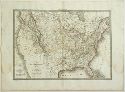
Carte des Etats Unis d'Amerique
Pierre LAPIE (1777 – 1851)
Alexander Emile LAPIE (fl 1809 – 1850)
“Carte des Etats Unis d'Amerique, du Canada, du Nouveau Brunswick et d'une partie de la No
Nice map of the United States dated in the cartouche 1832, showing the territories from the Atlantic to the Pacific coasts and the Gulf of Mexico with good details.
The map comes from the work of Pierre and Alexander Lapie “Atlas Universel de Geographie ancienne et moderne, precedé d'un precis de geographie physique et historique” published in Paris by Eimery, Fruger & Cie in 1833.
Still good example with margins around the platemark, with e the central vertical fold due to the binding and a large zone of waterstaining in the upper part mostly visible at verso otherwise in fairly good condition.
A blind stamp is located on the lower left hand corner and relates to the publisher's firm.
References:
Moreland-Bannister “Antique Maps a collector’s guide” Oxford 1989 pag.139.
Sarrut – Saint Edme “Biographie des Hommes du Jour”
Paris 1836 vol.2 part 1 pag.357 (Pierre Lapie)
Size in mm: 460ca x 605ca
Price: € 250,00